


Research Notes
The development of a GIS for New Deal Archaeology
Abstract
Bernard K. Means on the development of a GIS for New Deal Archaeology
I have recently launched an effort to create a GIS of all New Deal-funded archaeological investigations conducted in the 48 states that comprised the USA during the Great Depression (Means 2011). This effort was inspired by the persistent notion that New Deal archaeology was largely limited to the southeastern United States, where the generally warmer climate was seen as conducive to the lengthy field seasons that ensured continuous work for the unemployed (Lyon 1996). The large mound sites that dotted the southeastern USA also ensured that there would be sufficient work for the large relief crews seen as ideal from the perspective of federal officials. While it may prove true that the majority of New Deal archaeology was conducted in the southeast, it is also demonstrably true that the various ‘Alphabet Soup’ work relief programs – notably the Civilian Conservation Corps (CCC) and the Works Progress Administration/Work Projects Administration (WPA) – supported archaeological investigations throughout the USA. In my preliminary efforts to create a GIS for New Deal archaeology, I have determined that at least 75 percent of the 48 states that comprised the USA during the Great Depression had some form of federally funded work relief survey or excavation.
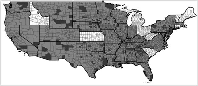
Figure 1. Map of 48 states of USA as they existed in the 1930s. States shown in white had no currently known New Deal archaeological surveys or excavations. Counties within states are highlighted when there is sufficient information to indicate work relief archaeology took place here.
Searches of various online resources – especially JSTOR – have facilitated the creation of a database that forms the core of the GIS. Additional sources consulted for the GIS include major published works (Fagette 1996; Lyon 1996) and the incomplete but extensive records of WPA projects housed in the National Anthropological Archives of the Smithsonian Institution in Suitland, Maryland. Online and published resources are critical to the creation of the GIS for New Deal Archaeology, but are sometimes frustratingly vague, from the perspective of creating a map highlighting the geographic extent of New Deal archaeology. In some instances, such as with Oregon, I have determined that New Deal archaeology projects were funded, but I was unable to specify exactly where in the state those projects took place.
For various reasons, the GIS for New Deal Archaeology is being limited to archaeological surveys and excavations. Considerable support was provided through the New Deal to stabilize and in some cases reconstruct archaeological ruins at heritage parks across the USA – but to include these types of projects would have made creating the GIS too daunting a task. Similarly, the various museum exhibit and curated projects that were supported are not currently being incorporated into the GIS (Nash 2012), although these will be added in the future.
Currently, the GIS for New Deal archaeology is recording archaeological surveys and excavations in terms of: the state and county in which they took place; the sponsor of the investigations; the funding source (e.g. CCC, WPA, etc.); the lead excavator(s); and, the duration of the excavations. These variables are not consistently recorded and even when they are, they may contradict one another. I plan to create a comprehensive database of all New Deal surveys and excavations and make this publicly available, so that fellow researchers can aid with correcting or completing entries, and make me aware of projects that may never have been published, or that are published but in relatively obscure local and state archaeology journals. The GIS for New Deal Archaeology will not only show that work relief archaeology encompassed the entire USA during the 1930s, but also the full extent of the legacy that modern American archaeology is built upon.
References
Fagette, P. 1996. Digging for Dollars: American Archaeology and the New Deal. Albuquerque: University of New Mexico Press.
Lyon, E. A. 1996. A New Deal for Southeastern Archaeology. Tuscaloosa: University of Alabama Press.
Means, B. K. 2011. The Future Meets the Past: Digital Mapping of New Deal Archaeology Projects Across the Lower 48 States. The SAA Archaeological Record 11. In Press.
Nash, S. 2012. The Great Depression Begets a Great Expansion: Field Museum Anthropology 1929–1941. In B. K. Means (ed) Shovel Ready: Archaeology and Roosevelt’s New Deal for America. Tuscaloosa: University of Alabama Press.